બીપરજોય વાવાઝોડુ: 125ની સ્પીડ, 7 થી 10 તારીખમાં આગાહી, અરબી સમુદ્રમાં ભારે કરંટ જોવા મળશે – depression has become active in the Arabian Sea
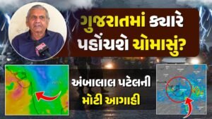
અરબી સમુદ્રમાં ડિપ્રેશન સક્રીય થયું છે અને હવે આગામી સમયમાં તેની શું અસરો થશે તે અંગે દેશના હવામાન વિભાગ દ્વારા માહિતી સતત આપવામાં આવી રહી છે. હાલ જે પ્રમાણે આજે માહિતી આપવામાં આવી છે તે મુજબ ડિપ્રેશન દક્ષિણ પોરબંદરથી લગભગ 1160 કિ.મી. ના અંતરે છે. અરબી સમુદ્રમાં બનેલી સિસ્ટમ પર હવામાન વિભાગ દ્વારા સતત નજર રાખવામાં આવી રહી છે. સિસ્ટમ હાલ દક્ષિણપૂર્વમાં અરબી સમુદ્રમાં છે અને તે ગોવાથી દક્ષિણ પશ્ચિમ તરફ છે અને તેનું ગોવાથી અંતર 920 કિ.મી. છે. જ્યારે મુંબઈથી દક્ષિણ-દક્ષિણપશ્ચિમમાં 1120 કિ.મી.ના અંતરે છે. આ સિવાય તે પોરબંદરથી અરબી સમુદ્રમાં દક્ષિણ ભાગે 1160 કિ.મી. અને કરાંચીથી 1520 કિ.મી.ના અંતરે છે.
આ પણ વાચો: ગુજરાત પર ત્રાટકશે વાવાઝોડું? જાણો સંભવીત રુટ વિશે
બિપરજોય વાવાઝોડુ બની ગયું

હવામાન વિભાગ દ્વારા તીવ્ર ગતિએ આંધી આવવાની શકયતા વ્યક્ત કરવામાં આવી રહી છે, જેમાં આજ થી 10 સુધીમાં પવનની ગતિ 125 કિ.મી. સુધી જવાની પણ શક્યતાઓ વ્યક્ત કરાઇ છે. જો વાવાઝોડું ગુજરાતના દરિયા કિનારા પર આવશે તેની અસર ગંભીર થઈ શકે છે. જોકે, હજુ સુધી આ પ્રકારની સંભાવના વ્યક્ત કરવામાં આવી નથી. પરંતુ તેના પર સતત નજર રાખવામાં આવી રહી છે. અરબી સમુદ્રમાં પશ્ચિમમધ્ય તથા દક્ષિણમાં પવનની ગતિ ડિપ્રેશન વાવાઝોડામાં પરિવર્તિત થવાની સાથે વધતી જશે. જે આજે 45-45 કિલોમીટર રહીને આગામી સમયમાં 125 સુધી જઈ શકે છે. આજે પૂર્વમધ્ય અરબી સમુદ્રમાં સિસ્ટમની અસર રહેશે.
7 જૂન: આંધી ફૂંકાશે અને પવનની ગતિ દરિયામાં 65 થી 75 કિલોમીટર પ્રતિકલાકની રહી શકે છે, જે વધીને 100 કિલોમીટર પ્રતિકલાક પણ થઈ શકે છે. કેરળ, કર્ણાટકા અને ગોવાના દરિયા કાંઠે પવનની ગતિ 40 થી 50 સુધી રહી શકે છે.
8 જૂન: પવનની ગતિ વધીને 80 થી 90 કિલોમીટર પ્રતિકલાકની ઝડપ રહે તેવી શકયતા છે. આ કારણે દેશના પશ્ચિમ ભાગમાં માછીમારોને ચેતવણી આપવામાં આવી છે, જેમાં ગુજરાતનો પણ સમાવેશ થાય છે. આ સાથે ગુજરાતના તમામ પોર્ટ પર 1 નંબરનું સિગ્નલ આપી દેવામાં આવ્યુ છે.
9 જૂન: અરબી સમુદ્રમાં બનેલી સિસ્ટમ વધુ મજબૂત થવાથી પવનની ગતિ 95 થી 105 કિલોમીટર પ્રતિકલાકની ઝડપે આંધી ફૂંકાવાની શકયતા છે. આ દરમિયાન પણ કર્ણાટક, ગોવા અને મહારાષ્ટ્રના દરિયા કાંઠા પર તેની અસર જોવા મળી શકે અને ત્યાં 60 કિલોમીટર પ્રતિકલાકની ગતિ સાથે પવન ફૂંકાવાની શકયતા છે.
10 જૂન: દરિયામાં વાવાઝોડું બનવાની શક્યતાઓ જોવાઈ રહી છે જોકે, આ મુદ્દે હવામાન વિભાગ સતત નજર રાખી રહ્યું છે. આ તારીખે પવનની ગતિ 115 થી 125 સુધી જઈ શકે છે અને તેના કારણે પૂર્વ મધ્ય અરબી સમુદ્ર અને દક્ષિણ અરબી સમુદ્રમાં ભારે કરંટ જોવા મળશે.
આ ૫ણ વાચો: ગુજરાતના તમામ પોર્ટ પર 1 નંબરનું સિગ્નલ, ડિપ્રેશન પોરબંદરથી 1160km દૂર, જાણો હવામાન વિભાગની આગાહી
A depression has become active in the Arabian Sea and now information is being
continuously provided by the Meteorological Department of the country about its effects in the future. As per the information given today, the depression is about 1160 km from South Porbandar. At a distance of. The system over the Arabian Sea is being continuously monitored by the Meteorological Department. The system is currently in the Southeast Arabian Sea and is southwest of Goa and its distance from Goa is 920 km. is While it is at a distance of 1120 km to the south-southwest from Mumbai. Apart from this, it is 1160 km south from Porbandar to the Arabian Sea. and is at a distance of 1520 km from Karachi.
The Meteorological Department is expressing the possibility of a strong storm, with wind speed of 125 kmph from today to 10. Possibilities of going up to have also been expressed. If the storm hits the coast of Gujarat, the impact can be severe. However, such a possibility has not yet been expressed. But it is being monitored continuously. The wind speed will increase over the west-central and south Arabian Sea as the depression develops into a cyclonic storm. Which can be 45-45 km today and can go up to 125 in the next time. The system will continue to affect the eastern Middle Arabian Sea today.
June 7: A gale will blow and the wind speed may be 65 to 75 kmph offshore, which may increase to 100 kmph. Wind speed may be 40 to 50 along the coast of Kerala, Karnataka and Goa.
June 8: Wind speed is likely to increase to 80 to 90 kmph. Due to this, fishermen in the western part of the country, including Gujarat, have been warned. Along with this, 1 signal has been given at all the ports of Gujarat.
June 9: Stronger system over Arabian Sea is likely to produce gale-force winds of 95 to 105 kmph. During this time also its impact can be seen on the coast of Karnataka, Goa and Maharashtra and there is a possibility of blowing wind with a speed of 60 km per hour.
June 10: There is a possibility of a storm forming at sea, however, the Meteorological Department is keeping a close eye on the issue. On this date, the wind speed may go up to 115 to 125 and due to this heavy currents will be seen in East Central Arabian Sea and South Arabian Sea.